Thursday, July 27, 2023

Chief Joseph Hwy -3- Dead Indian Summit

chief-joseph-hwy-3-dead-indian-summit.html    

Chief Joseph Hwy -3- Dead Indian Summit

September 8, 2009 Chief Joseph Hwy WY hwy 296 north

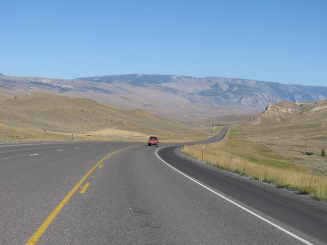
These pics are standing at the summit of Dead Indian pass. Chief Joseph took the Nez Perce up high on the pass while evading the pursuing US Army (see Chief Joseph hwy - the begining)... one of the Nez Perce was mortally wounded. Would be dead in a couple hours... no way to save him. They left his dead body on this very summit / overlook & left tracks leading Gen Howards army in pursuit of the high pass. They took the bait.

The gorge in these pics... about 4-5 miles to the right.... look for the cragly rock canyon in the valley to the right.... and remember thse pics as we will leave here and go up the road about 10 miles and there's a bridge that crosses this canyon, and you can see how deep it is. The pics of the gorge in the valley are the canyon of Clark's Fork River --Chief Joseph snuck the tribe down on the Low pass & escaped pursit once more. He is my hero too!


Content / Text coming


Under construction... enjoy pics for now


Chief Joseph Hwy -3- Dead Indian Summit


September 8, 2009 Chief Joseph Hwy WY hwy 296 north

These pics are standing at the summit of Dead Indian pass. Chief Joseph took the Nez Perce up high on the pass while evading the pursuing US Army (see Chief Joseph hwy - the begining)... one of the Nez Perce was mortally wounded. Would be dead in a couple hours... no way to save him. They left his dead body on this very summit / overlook & left tracks leading Gen Howards army in pursuit of the high pass. They took the bait.

The gorge in these pics... about 4-5 miles to the right.... look for the cragly rock canyon in the valley to the right.... and remember thse pics as we will leave here and go up the road about 10 miles and there's a bridge that crosses this canyon, and you can see how deep it is. The pics of the gorge in the valley are the canyon of Clark's Fork River --Chief Joseph snuck the tribe down on the Low pass & escaped pursit once more. He is my hero too!


Cody Wyoming TO Chief Joseph Hwy -1-

 Cody Wyoming to-chief-joseph-hwy-1.html  

Cody Wyoming TO Chief Joseph Hwy -1-

Yellowstone was booked up for Labor day weekend so passed thru to Cody Wy -- Buffalo Bill country-- the Absoroka mtns ... Absoroka(the Crow tribe) & Shoshone(the Snake) indian land.

North to Chief Joseph hwy -- This may be one of the greatest stories ever told; am honored I got to see, & smell the air where this took place. ***

the route the Nez Perce tribe took to outrun the US Army to Canada. Firefights & skirmishes w/ the Army all the way in order to keep from rounded up to a reservation... or killed by the Army. The previous year - 1876 Custers Army unit was wiped out humiliating the army & Washington DC. Howards army -- the 7th calvary-- was to take the Nez Perce to their new reservation ... some say the Army was out to settle the score for custer by killing the whole Nez Perce tribe.

Chief Joseph hwy in Wy/ MT where Chief Joseph led the Nez Perce tribe.... about 750 Nez Perce, on an 1,600 mile trek w/ the Army hunting them down to force them to a reservation....or kill them in the process. The Nez Perce fled several hundered miles, heading to Canada for freedom rather than be caged.... I stood where those brave warriors fought & traveled.... & said prayers for them. I stood on hallowed ground & said prayers.... for them & many friends. & at the place where they were finnally overtaken - Sept 8th, 1877- . some few miles before reaching their promised land of escape in Canada.

Onto the Beartooth Hwy, -- highest hwy in America-- 11,000 ft ... that was the hwy. peaks were higher. Clarks ford river was cut into stone & a gorge beyond description.

places like up on the Beartooth HWy in MT. 11,000+ ft Snowpack in places that is actually glaciers... or what's left of them. They'll be gone in 5 years. just glad I got to see them befor they're gone & some other magnificent places. It was litterally touching the heavens & many a prayer was offered up for friends & family. The starkness of the wilderness, high arid mountains, rivers & streams gut 1,000 ft gorges in limestone or granite rock. Water is available & plentiful in places. usually small crossroads of towns of a couple hundred population... fish camps for the fly fishermen trout fishing the streams. It is land that cannot be tamed.

Water. Clear water. all of it. Spring fed or snowpack runnoff. all rivers & lakes so clear you could see the rounded river rock 3to 4 feet on the riverbed. in places you could see small trout. It was a feeling of dipping up a glass of water & drinking. .... so clean & pure..... pure thin air.... no pollution.... no smog. I fly fished in many rivers & need to start "SAVE THE TROUT" ...&

Absoroka Mtn range in Wy.... where the Absoroka & Shoshone tribe ruled.... & Mtn goats/ sheep lived on the tall mtn peaks because the predator bears & cougars couldnt move to hunt them.


Cody, wyoming TO Chief Joseph - 1 - hwy

Yellowstone was booked up for Labor day weekend so passed thru to Cody Wy -- Buffalo Bill country-- the Absoroka mtns ... Absoroka(the Crow tribe) & Shoshone(the Snake) indian land.

North to Chief Joseph hwy -- This may be one of the greatest stories ever told; am honored I got to see, & smell the air where this took place. ***

the route the Nez Perce tribe took to outrun the US Army to Canada. Firefights & skirmishes w/ the Army all the way in order to keep from rounded up to a reservation... or killed by the Army. The previous year - 1876 Custers Army unit was wiped out humiliating the army & Washington DC. Howards army -- the 7th calvary-- was to take the Nez Perce to their new reservation ... some say the Army was out to settle the score for custer by killing the whole Nez Perce tribe.

Chief Joseph hwy in Wy/ MT where Chief Joseph led the Nez Perce tribe.... about 750 Nez Perce, on an 1,600 mile trek w/ the Army hunting them down to force them to a reservation....or kill them in the process. The Nez Perce fled several hundered miles, heading to Canada for freedom rather than be caged.... I stood where those brave warriors fought & traveled.... & said prayers for them. I stood on hallowed ground & said prayers.... for them & many friends. & at the place where they were finnally overtaken - Sept 8th, 1877- . some few miles before reaching their promised land of escape in Canada.

Onto the Beartooth Hwy, -- highest hwy in America-- 11,000 ft ... that was the hwy. peaks were higher. Clarks ford river was cut into stone & a gorge beyond description.

places like up on the Beartooth HWy in MT. 11,000+ ft Snowpack in places that is actually glaciers... or what's left of them. They'll be gone in 5 years. just glad I got to see them befor they're gone & some other magnificent places. It was litterally touching the heavens & many a prayer was offered up for friends & family. The starkness of the wilderness, high arid mountains, rivers & streams gut 1,000 ft gorges in limestone or granite rock. Water is available & plentiful in places. usually small crossroads of towns of a couple hundred population... fish camps for the fly fishermen trout fishing the streams. It is land that cannot be tamed.

Water. Clear water. all of it. Spring fed or snowpack runnoff. all rivers & lakes so clear you could see the rounded river rock 3to 4 feet on the riverbed. in places you could see small trout. It was a feeling of dipping up a glass of water & drinking. .... so clean & pure..... pure thin air.... no pollution.... no smog. I fly fished in many rivers & need to start "SAVE THE TROUT" ...&

Absoroka Mtn range in Wy.... where the Absoroka & Shoshone tribe ruled.... & Mtn goats/ sheep lived on the tall mtn peaks because the predator bears & cougars couldnt move to hunt them.