Wednesday, November 30, 2016

Dry off

Tracks of the StoneBear Copyright MCMLXIII Uncle Hargus ALL Rights reserved

ROF= Ring of fire Odyssey  MEF-H = Marine Expeditionary Force- Hargus 

Friday November 30, 2016       

 
Visitor stopped by today to dry off.


You never drink twice from the same stream. 

StoneBearTracks Copyright Uncle Hargus MCMLXIII ALL blog posts/photographs/video ALL Rights reserved 

ALL Blog posts/photographs/video Copyright MCMLXIII ALL Rights Reserved 


Monday, November 28, 2016

Independence Pass BTW 54

draft      

Tuesday, October 2, 2012

Independence Pass BTW 54

BTW #64 -  54      Back to the West Journey     Tracks of the StoneBear
Monday August 13, 2012

 
Tracks of the StoneBear Copyright MCMLXIII Uncle Hargus ALL Rights reserved

ROF= Ring of fire Odyssey  MEF-H = Marine Expeditionary Force- Hargus 


15 miles west of Twin Lakes, Colorado  
  
Independence Pass 12, 085' elev   ON the Continental Divide 
It took some doing to get here. On the road map it's Colo hwy 82 west from US hwy 24south -- south from Leadville, Colo -- also see the Leadville, Colo posts.

Twin Lakes, Colo is a neat little historical side-out.... pop 100. The lodge has been here for 100 years... a couple blocks of dirt streets. on west 5+ miles is the Twin Peaks camp in the San Isabel national Forest.... a refreshing stop. -- see the Twin Peaks -- Perseid's meteor shower post. 


Head out on Colo hwy 82west. This road will take you to Aspen, Colo. I don't care to see Aspen. I've already seen Vail and Breckenridge, Colo and wanted to throw up after riding through town. Also wanted to take a shower after being violated to seeing these aborations -- tourist ski resorts among grand majestic mountains -- in the Rockies. Maybe it's better in the winter snow.
Heading west on Colo hwy 82, up this valley, 1,200' mountains on each side. Rock formations are amazing. Thick mountain forest terrain in this valley, wind over the mountain stream on the left,.... over a bridge and then the stream is on the right.

 This is the same Lake Creek I listened to last night 100' from the Twin peaks campsite while watching the Perseid's meteor shower at 3am. This is more than a creek... it's 100' wide most places with a lot of flow over mountain rock bed. The beds are rounded rock from the millennia of erosion. Absolutely beautiful stream flowing down. We're driving upstream -- up the valley.


Ascending on a steep pace. At times the road grade is 6% and little Hiddalgo II is going 15mph up the mountain road..
Running in and out of rain. Mountain fog. Up and into the fog clouds.... Visability in a mile ranges from 10 miles to 200 yards. Valley is amazing. Ascending up some switchbacks / hairpin curves.
come to a valley headwaters. Winding creek through beaver dams. Mountains on every side.... up 2,000' vertical... Spectacular. Moist damp, wet road. Can see the road going up the mountain.
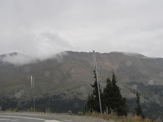
Drive on , ascending....stop at an overlook.... phenomenal view looking back down the valley. pix. Can now see the treeline on the mountains.... the point where forest evergreen pine trees grow.... and the line -- horizontal line on the mountains that are bare on the top.... just alpine tundra grass. No trees / vegetation will grow above a certain point on the mountain due to altitude ... harsh mountain wind erosion.


Switchback road up into the fog now. Visibility 200' now... press on to the summit.
Independence Pass -- it IS the Continental Divide. 12, 095' elev. Fog / rain... viz 100' at times. Wind 25+


I've got to climb out onto this place. Driving rain.... sideways rain. ... stinging rain. Cold, 39*. wind 30+.    Hike out to the actual peak. Fog. I'm it! ; there is no one else here. ?Where is everybody? ?Why isn't there anyone else here? Pristine mountain peak. ... raw / surreal. Wind is 25+ gusts. A brief gap in the clouds & can see the actual peak.
About 20 minutes to say a few prayers for Sons,... take in the stark, raw, cold element of this peak / pass. Evacuate and begin to head down.


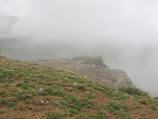
Descending the peak, stop at an overlook... maybe a thousand feet below... maybe 11,000' now and the clouds / fog part for a few minutes. Can't take pix fast enough. Fantastic view of the mountain ridges and valley with the headwaters. Down from the Continental Divide... this was a phenomenal place to see.

You never drink twice from the same stream. 

StoneBearTracks Copyright Uncle Hargus MCMLXIII ALL blog posts/photographs/video ALL Rights reserved 

ALL Blog posts/photographs/video Copyright MCMLXIII ALL Rights Reserved


Jasper AL 2


Tuesday, September 30, 2014

Jasper AL 2

 Tracks of the StoneBear Copyright MCMLXIII Uncle Hargus ALL Rights reserved

ROF= Ring of fire Odyssey  MEF-H = Marine Expeditionary Force- Hargus 

Tracks of the StoneBear  BNF = Banff, BC/ Alberta journey

ROF = Ring of Fire journey

British Columbia/ Alberta, Canada

Monday August 25, 2014  BNF 10  

Jasper, AL 2  

... that's Jasper, ALBERTA... NOT Jasper, Alabama; Big difference. 

Driving the Icefields Parkway the 1st time.... can't take pix fast enough... the Canadian Rockies... beyond description. 


Late in the afternoon we come into Jasper, Alberta... Canada... what a grand place!


Jasper is really a neat place. Surrounded by the Canadian Rockies... snow pack on some of the mountains... and it's late August. 


The Athabasca River runs through town.. the same river that runs down the Valley of the Icefileds Parkway. Yeah,... that beautiful drive with this river feeding the glacial lakes along the Parkway.


A good train station that is the northern end of the Banff National Park. This is the main "Via Rail" rail stop for JAsper/ Lake Louise/ Banff. The Via rail -- Canada's Amtrak passenger rail service-- route is from Toronto/ East, to Vancouver/ west origins. 

There is a private excursion train that goes down the Athabasca River Valley/ Icefields parkway route to Lake Louise and Banff; It's the Rocky Mountaineer.


The Rocky Mountaineer was in stations late afternoon. It's a private tour rail passenger train that does NOT travel at night. ALL rail transit is in the daylight for best viewing... that's great. You don't miss any of the spectacular scenery.  


Did I mention Jasper is a pretty neat place? 

A lot of small businesses... good food, outfitters, local grocery store - adequate but not a big safeway supermarket- but ok. The price of food is high in Canada; about 15%+ higher than the states. sometimes a little more.  


... a laundromat that had showers for patrons- tokens if you washed clothes, or I think you could buy a token for a couple $ & looked in one... they were private, doors locked, sink & mirror & adjacent shower stall. I thought this was pretty good to cater to the young kids backpacking & traveling, or ski bums... and I mean that affectionately for the young skiers.  


A lot of B&Bs for overflow when the motel lodging is booked. Also see the Jasper post on B&B lodging... it's about 1/2 price of the motels and good on your budget and it's not a youth hostel; it's private homes extra room or basement. 


It's not unusual to see an elk wandering through town. 


Went to the city library and checked email. It was in the temporary space in the city auditorium. I walked back into the hockey arena & took pix... also see that post. 


Drove up past the library,... up into the lakes above Jasper... to Patricia Lake... which was used as an experimental lake for boat research in the frigid arctic conditions. 


from wikipedia: 

Patricia Lake is notable for its involvement during World War II with Project Habbakuk, a plan to build an unsinkableaircraft carrier from an ice-based composite material termed "Pykrete".[3]
Initial studies of natural lake ice had been carried out at Lake Louise. In January 1943, Patricia Lake was chosen as the test site for building a prototype vessel.[1] The planned vessel was to be 2,000 feet (600 m) long and the prototype was to be a 1:10 scale model of this. In fact, the beam was to approximately this scale, but the length was only 60 feet, about a third of scale.[1]


****
Then up to Pyramid lake. beautiful with a motel lodge for tourists.


... and a really great Bear carving. 


Went Hwy 16 north of town a couple miles and drove out to Medicine Lake. Really beautiful and pristine. 


A magnificent mountain range down the left/ north side of the road... lake, river valley on the right.  


Drove on down the valley to Maligne Lake ... surrounded by Canadian Rockies snow cap peaks. My god it is so beautiful here. There's not a dozen cars on the road there and back. We've got Canadian Rockies without the tourists! 


Fished the lakes some; no luck today. T-bird usually can catch a couple trout in these lakes.  

Back up to Jasper mid afternoon.   Sunset pix are somewhat overcast sky.


You never drink twice from the same stream. 

StoneBearTracks Copyright Uncle Hargus MCMLXIII ALL blog posts/photographs/video ALL Rights reserved 

ALL Blog posts/photographs/video Copyright MCMLXIII ALL Rights Reserved 


Late in the day out to Old Fort Point... that will require another post it's too much more to put here.