ROF= Ring of Fire Odyssey
MEF-H = Marine Expeditionary Force- Hargus
Eire= Ireland journey
Friday April 26, 2019
The Burren
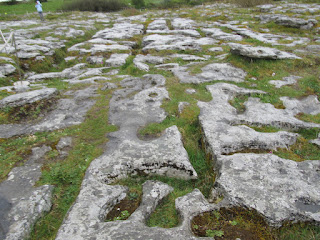
from wiki: The Burren (Irish: Boireann, meaning "great rock") is a region of environmental interest primarily located in northwestern County Clare, Ireland, dominated by glaciated karst (or sometimes glaciokarst[1]) landscape. It measures, depending on the definition, between 250 square kilometres (97 sq mi) and 560 square kilometres (220 sq mi). The name is most often applied to the area within the circle made by the villages of Tubber, Corofin, Kilfenora, Lisdoonvarna, and Ballyvaughan, and Kinvara in extreme south-western Galway, including the adjacent coastline.[2]
It is something to see this geological phenomenon. This massive limestone plain ... had to stop and walk around some.
Poulnabrone Altar/ Tomb is one of the distinct tombs in Ireland. This is about 8 miles south of Ballyvaughan on r480.
You never drink twice from the same stream.
Just because you wander doesn't mean you're lost.
Uncle Hargus: Last of the Independents
Have Bear,
Will Travel
StoneBearTracks Copyright Uncle Hargus MCMLXIII ALL blog posts/photographs/video ALL Rights reserved
ALL Blog posts/photographs/video Copyright MCMLXIII ALL Rights Reserved


