https://stonebeartracks.blogspot.com/2011/04/
Trinidad Lake st pk 1 Trinidad, Colorado
ITW 15
May 23
Trinidad Lake st pk Trinidad, Colorado
About 8 miles west on hwy 160west and camp here tonight.
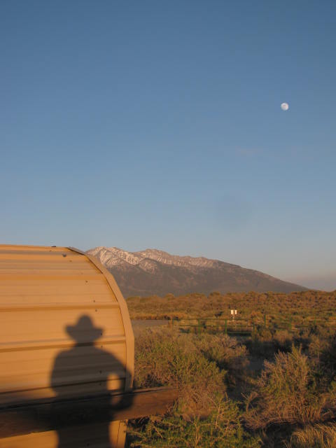
This lake / reservoir was scenic Colorado. Visability is some 40+ miles. Across the lake... that's Fishers Peak 9,600'.
This was a major landmark through history .... to the ancestral indian tribes, and the Santa Fe trail came through Raton Pass by this trail navigation marker.
This was a short travel day from Raton, New Mexico from mainenence / laundry day ect... This is agood stop for the eve. Cool and wind is about 15+ , small waves on the lake.
What I briefly saw of Trinidad I liked and will go back into town tommorrow to see what's there.


ITW 15
May 23
Trinidad Lake st pk Trinidad, Colorado
About 8 miles west on hwy 160west and camp here tonight.
This lake / reservoir was scenic Colorado. Visability is some 40+ miles. Across the lake... that's Fishers Peak 9,600'.
This was a major landmark through history .... to the ancestral indian tribes, and the Santa Fe trail came through Raton Pass by this trail navigation marker.
This was a short travel day from Raton, New Mexico from mainenence / laundry day ect... This is agood stop for the eve. Cool and wind is about 15+ , small waves on the lake.
What I briefly saw of Trinidad I liked and will go back into town tommorrow to see what's there.


ITW 15
May 23
Trinidad Lake st pk Trinidad, Colorado
About 8 miles west on hwy 160west and camp here tonight.
This lake / reservoir was scenic Colorado. Visability is some 40+ miles. Across the lake... that's Fishers Peak 9,600'.
This was a major landmark through history .... to the ancestral indian tribes, and the Santa Fe trail came through Raton Pass by this trail navigation marker.
This was a short travel day from Raton, New Mexico from mainenence / laundry day ect... This is agood stop for the eve. Cool and wind is about 15+ , small waves on the lake.
What I briefly saw of Trinidad I liked and will go back into town tommorrow to see what's there.
Tuesday, April 5, 2011
San Luis st pk camp
ITW 18
Tuesday May 25
San Luis st pk, Colorado
San Luis valley
Southern Colorada Hwy 12 west is a Scenic Byway through the foothills of the Rockies. Beautiful country. Snowcap peaks.
Through Stonewall county some "Flatiron" rock formations. /amazing to see.
Cuchara pass 9,941' elev
Laveta pass ... break out into Plains / arid plain / desert.
Hwy 160 west straight roads down to Plains. sagebrush forever.
Ft Garland. Onto Alamosa. North on hwy 17. pass by a Solar collector plant / project; interesting.
East to San Luis st park. another sign : Great Sand Dunes Nat Park.
Drive through desert. See several "Dirt Devils" ... Cyclone / Twister/ Funnels from sand. Late afternoon now.
San Luis Lake has a canal leading away to irrigate local ranches.
Snowcap Mtns on other side of Lake are Sangre de Cristo range. Stunningly beautiful in the arid high plains desert. Tranquil
Great Sand Dunes are at the bottom of range across Lakes.
San Luis Lake is not from Snowpack runoff down the mountain ridges... Snowpack Melt Sinks INTO mountain , then perocolates down through Sangre de Cristo Mountain range /// through earth, then rises in bowl lake at the bottom of the range. Amazing.
Desert air is thin, cool. Wind 10 -12+. Clear. Very peaceful.


ITW 18
Tuesday May 25
San Luis st pk, Colorado
San Luis valley
Southern Colorado Hwy 12 west is a Scenic Byway through the foothills of the Rockies. Beautiful country. Snowcap peaks.
Through Stonewall county some "Flatiron" rock formations. /amazing to see.
Cuchara pass 9,941' elev
Laveta pass ... break out into Plains / arid plain / desert.
Hwy 160 west straight roads down to Plains. sagebrush forever.
Ft Garland. Onto Alamosa. North on hwy 17. pass by a Solar collector plant / project; interesting.
East to San Luis st park. another sign : Great Sand Dunes Nat Park.
Drive through desert. See several "Dirt Devils" ... Cyclone / Twister/ Funnels from sand. Late afternoon now.
San Luis Lake has a canal leading away to irrigate local ranches.
Snowcap Mtns on other side of Lake are Sangre de Cristo range. Stunningly beautiful in the arid high plains desert. Tranquil
Great Sand Dunes are at the bottom of range across Lakes.
San Luis Lake is not from Snowpack runoff down the mountain ridges... Snowpack Melt Sinks INTO mountain , then perocolates down through Sangre de Cristo Mountain range /// through earth, then rises in bowl lake at the bottom of the range. Amazing.
Desert air is thin, cool. Wind 10 -12+. Clear. Very peaceful.
Tuesday May 25
San Luis st pk, Colorado
San Luis valley
Southern Colorada Hwy 12 west is a Scenic Byway through the foothills of the Rockies. Beautiful country. Snowcap peaks.
Through Stonewall county some "Flatiron" rock formations. /amazing to see.
Cuchara pass 9,941' elev
Laveta pass ... break out into Plains / arid plain / desert.
Hwy 160 west straight roads down to Plains. sagebrush forever.
Ft Garland. Onto Alamosa. North on hwy 17. pass by a Solar collector plant / project; interesting.
East to San Luis st park. another sign : Great Sand Dunes Nat Park.
Drive through desert. See several "Dirt Devils" ... Cyclone / Twister/ Funnels from sand. Late afternoon now.
San Luis Lake has a canal leading away to irrigate local ranches.
Snowcap Mtns on other side of Lake are Sangre de Cristo range. Stunningly beautiful in the arid high plains desert. Tranquil
Great Sand Dunes are at the bottom of range across Lakes.
San Luis Lake is not from Snowpack runoff down the mountain ridges... Snowpack Melt Sinks INTO mountain , then perocolates down through Sangre de Cristo Mountain range /// through earth, then rises in bowl lake at the bottom of the range. Amazing.
Desert air is thin, cool. Wind 10 -12+. Clear. Very peaceful.


ITW 18
Tuesday May 25
San Luis st pk, Colorado
San Luis valley
Southern Colorado Hwy 12 west is a Scenic Byway through the foothills of the Rockies. Beautiful country. Snowcap peaks.
Through Stonewall county some "Flatiron" rock formations. /amazing to see.
Cuchara pass 9,941' elev
Laveta pass ... break out into Plains / arid plain / desert.
Hwy 160 west straight roads down to Plains. sagebrush forever.
Ft Garland. Onto Alamosa. North on hwy 17. pass by a Solar collector plant / project; interesting.
East to San Luis st park. another sign : Great Sand Dunes Nat Park.
Drive through desert. See several "Dirt Devils" ... Cyclone / Twister/ Funnels from sand. Late afternoon now.
San Luis Lake has a canal leading away to irrigate local ranches.
Snowcap Mtns on other side of Lake are Sangre de Cristo range. Stunningly beautiful in the arid high plains desert. Tranquil
Great Sand Dunes are at the bottom of range across Lakes.
San Luis Lake is not from Snowpack runoff down the mountain ridges... Snowpack Melt Sinks INTO mountain , then perocolates down through Sangre de Cristo Mountain range /// through earth, then rises in bowl lake at the bottom of the range. Amazing.
Desert air is thin, cool. Wind 10 -12+. Clear. Very peaceful.
Monday, April 4, 2011
Wolf Creek Pass Colorado ascent
ITW 19
Thursday May 27
Wolf Creek Pass, Colorado ascent
Park Creek camp, Rio Grande nat forest
Sleeping 40' from the river -- the mountain headwaters of The South Fork of the Rio Grande River --, the swishing sound of water flowing down the mountains makes for some really peaceful sleep; I recommend it - highly.
Still heading west down through the 4 corners area... eventually to Chinle, Arizona. After seeing Canyon de Chelly, will head north through the Rockies to Montana.
The engine heated up high climbing this ascent. Big trucks used low gear up, and down.
There's a reason this place has snow-pack everywhere. It's june and it's 40*. Elev is 10,863'... and that's the gap / pass to get through this part of the southern Rocky Mountains.
This was a major route west known as the Continental Divide trail. This is the main way to through the Rocky mountains to get to Southwest Colorado. ... otherwise you have to go way north up to Telluride,... or back east to the Raton Pass (the Santa Fe trail gap ).


ITW 19
Thursday May 27
Wolf Creeek Pass, Colorado ascent
Park Creek camp, Rio Grande nat forest
Sleeping 40' from the river -- the mountain headwaters of The South Fork of the Rio Grande River --, the swishing sound of water flowing down the mountains makes for some really peaceful sleep; I reccommend it - highly.
Still heading west down through the 4 corners area... eventually to Chinle, Arizona. After seeing Canyon de Chelly, will head north through the rockies to Montana.
The engine heated up high climbing this ascent. Big trucks used low gear up, and down.
There's a reason this place has snowpack everywhere. It's june and it's 40*. Elev is 10,863'... and that's the gap / pass to get through this part of the southern Rocky Mountains.
This was a major route west known as the Continental Divide trail. This is the main way to through the Rocky mountains to get to Southwest Colorado. ... otherwise you have to go way north up to Telluride,... or back east to the Raton Pass (the Santa Fe trail gap.
Thursday May 27
Wolf Creek Pass, Colorado ascent
Park Creek camp, Rio Grande nat forest
Sleeping 40' from the river -- the mountain headwaters of The South Fork of the Rio Grande River --, the swishing sound of water flowing down the mountains makes for some really peaceful sleep; I recommend it - highly.
Still heading west down through the 4 corners area... eventually to Chinle, Arizona. After seeing Canyon de Chelly, will head north through the Rockies to Montana.
The engine heated up high climbing this ascent. Big trucks used low gear up, and down.
There's a reason this place has snow-pack everywhere. It's june and it's 40*. Elev is 10,863'... and that's the gap / pass to get through this part of the southern Rocky Mountains.
This was a major route west known as the Continental Divide trail. This is the main way to through the Rocky mountains to get to Southwest Colorado. ... otherwise you have to go way north up to Telluride,... or back east to the Raton Pass (the Santa Fe trail gap ).


ITW 19
Thursday May 27
Wolf Creeek Pass, Colorado ascent
Park Creek camp, Rio Grande nat forest
Sleeping 40' from the river -- the mountain headwaters of The South Fork of the Rio Grande River --, the swishing sound of water flowing down the mountains makes for some really peaceful sleep; I reccommend it - highly.
Still heading west down through the 4 corners area... eventually to Chinle, Arizona. After seeing Canyon de Chelly, will head north through the rockies to Montana.
The engine heated up high climbing this ascent. Big trucks used low gear up, and down.
There's a reason this place has snowpack everywhere. It's june and it's 40*. Elev is 10,863'... and that's the gap / pass to get through this part of the southern Rocky Mountains.
This was a major route west known as the Continental Divide trail. This is the main way to through the Rocky mountains to get to Southwest Colorado. ... otherwise you have to go way north up to Telluride,... or back east to the Raton Pass (the Santa Fe trail gap.